ニュース
2025年09月25日
学生生活【多言語対応】塚本学長の防災ひとことメモ Ver.1(2025年9月)を掲載しました
山梨英和大学:塚本学長の防災ひとことメモ Ver.1(2025年9月)
Q:南海トラフ地震は山梨にも影響しますか?
Answer:はい、影響します。
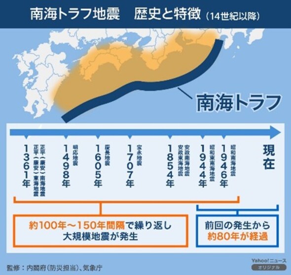
大阪に10年ほど住んでいましたが、毎日のようにメディアでは南海トラフ地震について目にしました。気象庁によれば、「南海トラフ地震は、駿河湾から日向灘沖にかけてのプレート境界を震源域として100~150年間隔で繰り返し発生してきた大規模地震です。」と説明されています。想定される最大規模の地震が発生した場合、静岡県から宮崎県にかけて震度7を記録する可能性もあります。また、太平洋沿岸では10m前後の津波も予測されています。
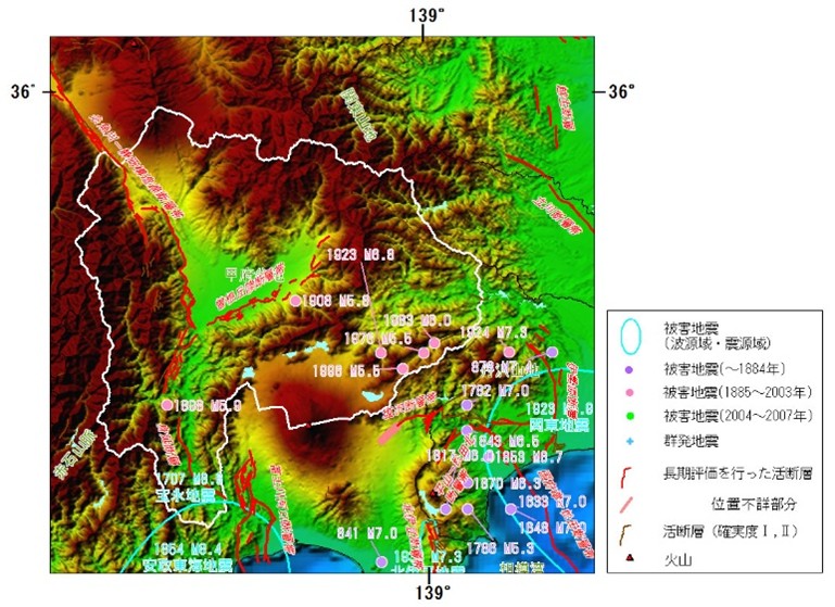
では、少し内陸の山梨県はどうでしょう?地震調査研究推進本部の調査によれば、甲府盆地の南と西側に断層があり、過去にその周辺でM6-M8クラスの地震が発生しています。
*資料:気象庁、地震調査研究推進本部事務局(文部科学省研究開発局地震火山防災研究課)
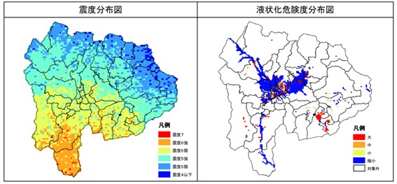
南海トラフ地震による山梨県への影響は、震度5強から6強の強い揺れが予測されています。古い建物やアパートの倒壊リスクが高まり、火災が発生します。山間部の多い山梨県では土砂崩れなどに注意する必要があります。また、甲府市や笛吹市などの都市部では、建物の倒壊や家具の転倒が起こりやすく、液状化現象が現れ、通行などが困難になることも想定されています。また、古い木造住宅が多く存在する地域では、耐震性が不十分な建物が多く、山間部の村落や小規模な集落でも、古い住宅の倒壊が懸念され、救助活動が困難になる可能性があります。(山梨県公式ホームページ参照)
国が公表した山梨県の被害の想定によると、最悪の場合、山梨県では死者はおよそ300人で、このうち建物倒壊がおよそ300人、土砂災害がおよそ10人、建物の全壊はおよそ7900棟で、このうち揺れがおよそ5900棟、火災がおよそ1400棟、液状化がおよそ600棟、土砂災害がおよそ100棟、水道の断水による影響は地震の翌日でおよそ33万人、1か月後でもおよそ3万6000人、下水道が利用できなくなるのは地震直後でおよそ49万人、1週間後でおよそ2万8000人、停電は地震発生直後におよそ47万戸、道路の被害はおよそ720か所、避難者は地震の翌日でおよそ4万3000人、1週間後が最も多くおよそ9万5000人、1か月後でもおよそ7万4000人。
さて、この情報を受けて、個人として、またコミュニティーとして、そして、行政では、どのような準備をしていけばいいのでしょうか?それは次回にご説明します。
Yamanashi Eiwa Collage: Disaster Prevention Memo by President Tsukamoto Ver. 1 (September 2025)
Q: Will the Nankai Trough earthquake affect Yamanashi?
Answer: Yes, it will.
I lived in Osaka for about 10 years, and I saw reports about the Nankai Trough earthquake in the media almost every day. According to the Japan Meteorological Agency, “The Nankai Trough earthquake is a large-scale earthquake that has repeatedly occurred at intervals of 100 to 150 years, with its epicenter zone spanning the plate boundary from Suruga Bay to the offshore area of Hyuga-nada.” If the maximum anticipated magnitude earthquake occurs, it could potentially register seismic intensity 7 from Shizuoka Prefecture to Miyazaki Prefecture. Additionally, tsunamis around 10 meters high are predicted along the Pacific coast.
So, what about Yamanashi Prefecture, slightly inland? According to research by the Headquarters for Earthquake Research Promotion, faults exist to the south and west of the Kofu Basin, and earthquakes of magnitude 6 to 8 have occurred in the surrounding area in the past.
*Source: Japan Meteorological Agency, Headquarters for Earthquake Research Promotion (Ministry of Education, Culture, Sports, Science and Technology, Research and Development Bureau, Earthquake and Volcano Disaster Prevention Research Division)
The impact of a Nankai Trough earthquake on Yamanashi Prefecture is predicted to include strong shaking of seismic intensity 5+ to 6+. This increases the risk of collapse for older buildings and apartments, leading to fires. Given Yamanashi’s mountainous terrain, caution is needed regarding landslides and similar hazards. In urban areas like Kofu City and Fuefuki City, building collapses and furniture overturning are likely. Liquefaction is also anticipated, potentially making passage difficult. Furthermore, in areas with many older wooden houses, numerous buildings lack sufficient seismic resistance. Collapses of old houses are a concern even in mountain villages and small settlements, potentially hindering rescue operations. (Refer to Yamanashi Prefecture’s official website)
According to the damage estimates for Yamanashi Prefecture published by the national government, in the worst-case scenario, Yamanashi Prefecture could see approximately 300 fatalities. Of these, approximately 300 would be due to building collapse, and approximately 10 due to landslides. Approximately 7,900 buildings would be completely destroyed, of which approximately 5,900 would be due to shaking, approximately 1,400 due to fire, and approximately 600 due to liquefaction. landslides affecting about 100 buildings. Water supply disruptions would affect about 330,000 people the day after the earthquake and about 36,000 people one month later. Sewer system outages would affect about 490,000 people immediately after the earthquake and about 28,000 people one week later. Power outages would affect about 470,000 households immediately after the earthquake, Road damage affected approximately 720 locations. Evacuees numbered approximately 43,000 the day after the earthquake, peaking at approximately 95,000 one week later, and still approximately 74,000 one month later.
So, given this information, what preparations should individuals, communities, and governments make? We’ll explain that next time.
山梨英和大学:塚本校长防灾简讯 Ver.1(2025年9月)
问:南海海槽地震会影响山梨吗?
答:是的,会产生影响。
我在大阪居住约十年期间,几乎每天都能在媒体上看到关于南海海槽地震的报道。据气象厅说明:“南海海槽地震是以骏河湾至日向滩外海板块边界为震源区,每隔100至150年反复发生的大规模地震。“若发生预想中的最大规模地震,静冈县至宫崎县可能出现震度7的强震。太平洋沿岸地区预计将遭遇10米左右的海啸。
那么稍内陆的山梨县情况如何?地震调查研究推进本部的调查显示,甲府盆地南侧与西侧存在断层,历史上该区域周边曾发生过M6-M8级地震。
*资料来源:气象厅、地震调查研究推进本部事务局(文部科学省研究开发局地震火山防灾研究课)
南海海槽地震对山梨县的影响预计为震度5强至6强的强烈摇晃。老旧建筑和公寓倒塌风险升高,可能引发火灾。山地众多的山梨县需警惕泥石流等灾害。此外,在甲府市、笛吹市等城市区域,建筑物倒塌、家具倾覆现象易发,液化现象可能导致道路通行困难。在老旧木造住宅密集区域,大量建筑抗震性能不足,山区村落及小型聚居地亦存在老旧住宅倒塌风险,可能导致救援行动受阻。(参照山梨县官方网站)
根据国家公布的山梨县灾害预估,最坏情况下该县死亡人数约达300人,其中约300人死于建筑物倒塌,约10人死于泥石流灾害。建筑物全毁数量约7900栋,其中约5900栋因震动倒塌,约1400栋因火灾损毁,约600栋因液化现象受损。泥石流灾害约100栋;地震次日约33万人受自来水断供影响,一个月后仍有约3.6万人受影响;地震后立即约49万人无法使用下水道,一周后约2.8万人受影响;地震发生后立即约47万户停电,道路受损约720处,避难者在地震次日约4.3万人,一周后达到峰值约9.5万人,一个月后仍有约7.4万人。
那么,面对这些信息,个人、社区以及行政部门应如何做好准备呢?这将在下期为您详细说明。
山梨瑛和大學:塚本校長對防災的話 Ver.1 (2025年9月)
問:南海槽地震會影響山梨縣嗎?
答:是的,會影響到我們。
我在大阪住了 10 年,每天都在媒體上看到南海槽地震。根據日本氣象廳的資料,「南海海槽地震是每隔 100 到 150 年重複發生的大型地震,震央位於駿河灣和日向灘外的板塊邊界上」。解釋如下。在可能發生最大地震的情況下。從靜岡縣到宮崎縣有可能發生烈度 7 級的地震。太平洋沿岸也預測會發生 10 公尺左右的海嘯。
稍為內陸的山梨縣又如何呢?根據地震研究推進本部的調查,甲府盆地的南側和西側有一條斷層線,該地區過去曾發生過 M6-M8 級地震。
資料來源:日本氣象廳,地震研究振興本部事務局(文部科學省研究發展局地震火山防災研究科)。
預測南海槽地震對山梨縣的影響為 5 級以上至 6 級以上的強震。老舊建築物和公寓倒塌和發生火災的風險將會增加。山梨縣多山區,人們需要小心山崩。在甲府市和府福市等市區,建築物很可能倒塌和傢俱傾倒,預計還會發生液化現象,難以通行。此外,在舊式木造房屋眾多的地區,有許多建築物的抗震能力不足,即使在山村和小聚落,也擔心舊式房屋可能會倒塌,這可能會造成救援行動的困難。(請參閱山梨縣官方網站)
根據政府公布的山梨縣損失預估,在最糟的情況下,山梨縣將有約 300 人死亡,其中約 300 人受到倒塌建築物的影響,約 10 人受到山崩的影響,約 7,900 棟建築物完全毀壞,其中約 5,900 棟建築物受到震動,約 1,400 棟建築物受到火災的破壞,約 600 棟建築物受到液化的破壞,約 100 棟建築物受到山崩的破壞,約 100 棟建築物受到水災的破壞。約有 100 座建築物受到山崩影響;約有 330,000 人在震後當天受到停水影響,一個月後有 36,000 人受到停水影響;約有 490,000 人在震後即時無法使用下水道,一個星期後有 28,000 人無法使用下水道;約有 470,000 戶在震後即時停電,約有 720 條道路受損、震後當天的疏散人數約為 43,000 人,一週後的疏散人數約為 95,000 人,一個月後的疏散人數約為 74,000 人。
因此,鑑於這些資訊,作為個人、社區和政府,您應該做哪些準備?我們將在下一期中解釋。
야마나시 에이와 대학: 총장의 방재 한마디 메모 No.1 (2025년 9월)
Q: 난카이 해곡 지진은 야마나시에도 영향을 미칩니까?
답변: 네, 영향을 미칩니다.
오사카에서 10년 정도 살았는데, 매일같이 미디어에서 난카이 해곡 지진에 관한 소식을 접했습니다. 기상청에 따르면, “난카이 해곡 지진은 스루가 만에서 히우가나다 앞바다에 이르는 판 경계를 진원지로 100~150년 간격으로 반복 발생해 온 대규모 지진입니다.”라고 설명하고 있습니다. 예상되는 최대 규모의 지진이 발생할 경우, 시즈오카현에서 미야자키현에 걸쳐 진도 7을 기록할 가능성도 있습니다. 또한 태평양 연안에서는 10m 전후의 쓰나미도 예측되고 있습니다.
그렇다면 내륙 쪽인 야마나시현은 어떨까요? 지진조사연구추진본부의 조사에 따르면, 고후 분지의 남쪽과 서쪽에 단층이 있으며, 과거 그 주변에서 M6-M8급 지진이 발생한 바 있습니다.
*자료: 기상청, 지진조사연구추진본부 사무국(문부과학성 연구개발국 지진화산방재연구과)
난카이 해곡 지진으로 인한 야마나시현의 영향은 진도 5강에서 6강에 이르는 강한 흔들림이 예상됩니다. 오래된 건물이나 아파트의 붕괴 위험이 높아지고 화재가 발생합니다. 산간 지역이 많은 야마나시현에서는 산사태 등에 주의해야 합니다. 또한 고후시나 후에부키시 등의 도시 지역에서는 건물 붕괴나 가구 전도가 발생하기 쉬우며, 액상화 현상이 나타나 통행 등이 어려워질 것으로 예상됩니다. 또한 오래된 목조 주택이 많이 존재하는 지역에서는 내진성이 부족한 건물이 많으며, 산간 지역의 마을이나 소규모 집락에서도 오래된 주택의 붕괴가 우려되어 구조 활동이 어려워질 가능성이 있습니다. (야마나시현 공식 홈페이지 참조)
국가가 공표한 야마나시현 피해 예상에 따르면 최악의 경우 야마나시현에서는 사망자가 약 300명, 이 중 건물 붕괴로 약 300명, 토사 재해로 약 10명, 건물 전소는 약 7,900동으로 이 중 흔들림으로 약 5,900동, 화재로 약 1,400동, 액상화로 약 600동, 토사 재해 약 100동, 상수도 단수로 인한 영향은 지진 다음 날 약 33만 명, 1개월 후에도 약 3만 6천 명, 하수도가 이용 불가능해지는 것은 지진 직후 약 49만 명, 1주일 후 약 2만 8천 명, 정전은 지진 발생 직후 약 47만 호, 도로 피해는 약 720곳, 피난민은 지진 다음 날 약 4만 3천 명, 1주일 후가 가장 많아 약 9만 5천 명, 1개월 후에도 약 7만 4천 명.
자, 이 정보를 바탕으로 개인으로서, 또한 지역사회로서, 그리고 행정 기관에서는 어떤 준비를 해야 할까요? 그 내용은 다음 시간에 설명드리겠습니다.
Colégio Eiwa de Yamanashi: Memorando do Presidente Tsukamoto sobre Prevenção de Desastres Ver. 1 (setembro de 2025)
P: O terremoto da Fossa de Nankai afetará Yamanashi?
Resposta: Sim, afetará.
Morei em Osaka por cerca de dez anos e vi reportagens sobre o terremoto da Fossa de Nankai na mídia quase diariamente. De acordo com a Agência Meteorológica do Japão, “o terremoto da Fossa de Nankai é um terremoto de grande escala que ocorreu repetidamente em intervalos de 100 a 150 anos, com seu epicentro ao longo da fronteira da placa que se estende da Baía de Suruga até a área offshore de Hyūga-nada”. Caso ocorra o terremoto de magnitude máxima prevista, poderá ser registrada uma intensidade sísmica de 7 na província de Shizuoka até a província de Miyazaki. Além disso, prevê-se a ocorrência de tsunamis de cerca de 10 metros ao longo da costa do Pacífico.
Então, e quanto à província de Yamanashi, um pouco mais para o interior? De acordo com pesquisas realizadas pela Sede de Promoção de Pesquisas Sísmicas, existem falhas ao sul e a oeste da Bacia de Kofu, e terremotos de magnitude 6 a 8 ocorreram na área circundante no passado.
*Fonte: Agência Meteorológica do Japão, Sede para Promoção de Pesquisas Sísmicas (Ministério da Educação, Cultura, Esportes, Ciência e Tecnologia, Departamento de Pesquisa e Desenvolvimento, Divisão de Pesquisa para Prevenção de Desastres Sísmicos e Vulcânicos)
Prevê-se que o impacto de um terremoto na Fossa de Nankai na província de Yamanashi inclua fortes tremores com intensidade sísmica de 5+ a 6+. Isso aumenta o risco de colapso de edifícios antigos e blocos de apartamentos, levando a incêndios. Dado o terreno montanhoso de Yamanashi, é necessário ter cuidado com deslizamentos de terra e riscos semelhantes. Além disso, em áreas urbanas como as cidades de Kōfu e Fuefuki, é provável que ocorram desabamentos de edifícios e tombamento de móveis. Prevê-se a ocorrência de fenômenos de liquefação, o que poderá dificultar a passagem. Além disso, em áreas com muitas casas antigas de madeira, vários edifícios não têm resistência sísmica suficiente. O desabamento de casas antigas também é uma preocupação em aldeias montanhosas e pequenos povoados, o que poderá dificultar as operações de resgate. (Consulte o site oficial da província de Yamanashi)
De acordo com as projeções de danos publicadas pelo governo nacional para a província de Yamanashi, no pior cenário, o número de mortes na província poderia chegar a aproximadamente 300 pessoas. Destas, aproximadamente 300 seriam devido ao colapso de edifícios e aproximadamente 10 devido a deslizamentos de terra. Aproximadamente 7.900 edifícios seriam completamente destruídos, dos quais aproximadamente 5.900 seriam devido a tremores, aproximadamente 1.400 devido a incêndios e aproximadamente 600 devido à liquefação. Os deslizamentos de terra afetariam aproximadamente 100 edifícios. As interrupções no abastecimento de água afetariam aproximadamente 330.000 pessoas no dia seguinte ao terremoto e aproximadamente 36.000 pessoas um mês depois. A indisponibilidade do sistema de esgoto afetaria aproximadamente 490.000 pessoas imediatamente após o terremoto e aproximadamente 28.000 pessoas uma semana depois. As quedas de energia afetariam aproximadamente 470.000 residências imediatamente após o terremoto. Os danos nas estradas afetaram aproximadamente 720 locais. O número de evacuados foi de aproximadamente 43.000 no dia seguinte ao terremoto, atingindo um pico de aproximadamente 95.000 uma semana depois e permanecendo em aproximadamente 74.000 mesmo um mês depois.
Então, com base nessas informações, quais preparativos devem ser feitos por indivíduos, comunidades e autoridades locais? Explicaremos isso na próxima vez.